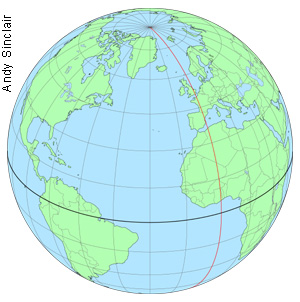
The Greenwich Meridian
…where east meets west
Latitude and Longitude
 Lines of latitude and longitude form the grid system used on globes, maps and charts. Latitude is a measure of how far north or south somewhere is from the Equator; longitude is a measure of how far east or west it is from the Prime Meridian. Whilst lines (or parallels) of latitude all run parallel to the Equator, lines (or meridians) of longitude all converge at the Earth’s North and South Poles. The north–south line passing through any particular point on the Earth’s surface is known as the “local meridian”.
Although the Equator is the obvious zero point from which to measure latitude, there is no equivalent point from which to measure longitude. In 1884, an international conference decided that the Greenwich Meridian, as defined by the Airy Transit Circle at the Royal Observatory, Greenwich, should be adopted as the Prime or Zero Meridian for the World.
Latitude and longitude are both measured in degrees. Each degree (°) is subdivided into 60 minutes (') and each minute into 60 seconds ("). Each degree of latitude corresponds to a distance on the Earth‘s surface of about 111 km. Each degree of longitude however, corresponds to a distance that varies with latitude. The distance is about 111 km at the Equator, reducing to 0 km at the Poles.
 Although it is often convenient to think of the Earth as being spherical, in reality, its shape approximates more closely to that of an ellipsoid – a sphere that is flattened towards the poles. As a result there is more than one way in which latitude is commonly measured.
Geocentric latitude is measured from the centre of the ellipsoid. Geodetic or geographic latitude – which is what is normally measured – is the angle between the plane of the Equator and the line, which is normal to the ellipsoid at the point of interest. Unlike geocentric latitude, this line does not typically pass through the centre of the ellipsoid. Whenever the unqualified term latitude is used, it will normally mean the geographic latitude.
On the WGS84 ellipsoid, the length of a degree of latitude increases from 110.574 km at the equator to 111.694 km at the poles. Geographic and geocentric latitudes can differ by as much as 12 minutes of arc, an amount equivalent to a distance of more than 30 km on the ground.